Topic 1: The Third Intifada
Why in news: Hamas has launched thousands of rockets and sent in its fighters into southern Israel. Some observers have referred to the latest escalation as the beginning of the “Third Intifada”.
The conflict
- This is the latest chapter in a long history of conflict in the region.
- Zionism — an ethno-nationalist movement which sought to establish a homeland for the Jewish people in Palestine — emerged in the late 19th century.
- The support for a Jewish nation grew significantly in the aftermath of World War II, as the horrors of the Nazi Holocaust of Jewish people came to be fully known.
- Thus, in 1948, with the support of the United Nations and the British, who had taken over control of the region after the Ottomans, Israel was born.
- As per the Partition Plan adopted by the UN in 1947, the British territory of Palestine would be divided into a Jewish and an Arab state.
- But almost immediately, war broke out between Zionist settlers, who had been thronging to Palestine, and Arabs.
- The first Arab-Israeli Warended in 1949 with Israel’s victory — in no small part due to support from the West — and the displacement of 750,000 Palestinians.
- The territory was divided into 3 parts:
- the Jewish Israel,
- the Arab West Bank and
- Gaza Strip.
- However, this failed to resolve the conflict which continues till date.
- The territory was divided into 3 parts:
- Israel has rapidly modernised and strengthened itself, with the support of the West, and expanded its occupation of Palestine beyond the boundaries set forth in the 1947 UN plan.

A third Intifada
- Intifada is an Arabic word that means to ‘shake off’.
- It came into popular usage in 1987, with Palestinians using it to describe their uprising against the Israeli presence in the West Bank and Gaza.
- The First Intifada lasted from 1987 to 1993, and the Second Intifada from 2000-2005.
- Since the end of the Second Intifada, tensions between Israel and Palestine have not quieted down.
- Many have been wary of a ‘Third Intifada’ for years, especially amidst the rise of the ultranationalist far-right in Israel with its extreme position on Palestine.
Topic 2: National Framework for Climate Services
Why in news: Spearheaded by the India Meteorological Department (IMD) India is launching a National Framework for Climate Services (NFCS).
Key details:
- It envisions to bring a seamless working platform for users of climate information and services, and help decide and mitigate climate risks for key sectors such as:
- agriculture,
- energy,
- disaster management,
- health and
- water.
-
TheGlobal Framework for Climate Services:
- The Global Framework for Climate Services (GFCS) is a partnership of governments and organisations at a global level, for the production and better usage of climate information and services.
- The GFCS aims to facilitate researchers and users of climate information and services to join hands in order to make informed and actionable decisions for the long-term betterment.
- The announcement to establish a GFCS was made during the third World Climate Conference held in Geneva in 2009.
- This framework is led by National Meteorological and Hydrological Services (NMHS) in their respective nations.
- It includes active participation of policymakers, planners, investors and vulnerable communities or sectors, as they need climate information and services in a user-friendly format, so that they can prepare for expected trends and changes in the long run.
- GFCS envisages to generate high-quality data from national and international databases on temperature, rainfall, wind, soil moisture and ocean conditions and other vital weather parameters.
- This is aimed at creating long-term historical averages of these parameters, as well as maps, risk and vulnerability analyses, assessments and long-term projections and scenarios.
- The five major components under GFCS are:
- Observations and Monitoring,
- Research, Modelling and Prediction,
- Climate Services Information System,
- User Interface Platform and
- Capacity Building.
- At present, the priority sectors where the GFCS focuses upon are:
- agriculture and food security,
- energy,
- health,
- water and
- disaster risk reduction.
-
Role of the NFCS:
- In lines with the global framework, the national framework will be based on country-specific weather and stakeholder needs.
- Unlike the GFCS, the nodal agency for the formulation and implementation of the national framework in India will be the IMD.
- Along with the identified sectors of focus, India could add other relevant sectors like transport, tourism and other emerging sectors from time to time.
- Initially, the NFCS will work in bridging functioning gaps between the various agencies who require climate services.
Need and significance of NFCS:
- IMD has gained a remarkable hold on providing high-quality weather services for the country and its South Asian neighbours.
- The IMD makes daily weather forecasts and season predictions for the winter, summer and the monsoon seasons.
- Over the decades, the Met department steadily upgraded the number of ground-based weather observation stations and radars.
- But, there remain many gap areas across terrains and the seas, wherein no weather data is available.
- There is a lack of long-term (100 years or more) climatological data from the Himalayan regions, the oceans, besides inexistence of radar and satellite-based climatology.
- This is one of the major reasons why the IMD could make limited in providing climate predictions (typically long-term, example decadal predictions).
- With NFCS, the Met department aims to:
- strengthen the observational network on land and the seas,
- improve the data inflow and
- eventually use it to run weather and climate models for deriving climate predictions.
- The framework aims to support efforts to prepare for new climate conditions and adapt to their impacts on water supplies, health risks, extreme events, farm productivity, infrastructure placement, power and energy generation and others.
Topic 3 : Israel’s Iron Dome
Why in news: The recent attack on Israel has raised concerns over Israel’s defence system – the Iron Dome.
What is the Iron Dome?
- It is a short-range, ground-to-air, air defence system that includes a radar and Tamir interceptor missiles that track and neutralise any rockets or missiles aimed at Israeli targets.
- It is used for countering rockets, artillery & mortars (C-RAM) as well as aircraft, helicopters and unmanned aerial vehicles.
- The Iron Dome was deployed in 2011.
Working of the iron dome:
- The Iron Dome has three main systems that work together to provide a shield over the area where it is deployed, handling multiple threats. It has:
- a detection and tracking radar to spot any incoming threats,
- a battle management and weapon control system (BMC)
- The BMC basically liaises between the radar and the interceptor missile.
- a missile firing unit.
- It is capable of being used in all weather conditions, including during the day and night.

Topic 4 : The Yom Kippur war
Why in news: The surprise attack by Hamas on Israel has brought back memories of the Yom Kippur war, which started 50 years and a day ago, and reset equations in the Middle East forever.
About the Yom Kippur war:
- The Yom Kippur war, or the October war, or the Ramadan war, was fought between Israel on one side and Egypt and Syria on the other, from October 6 to 25, 1973.
- It is also called the Fourth Arab-Israeli war, coming after three wars in 1949, 1956, and 1967.
- After its decisive victory in the Six-Day War of 1967, Israel had captured territories from its neighbours, including the Golan Heights from Syria and the Sinai Peninsula from Egypt.
- Six years later, the Egypt and Syria launched a coordinated attack on Israel and Israel was able to contain it.
- The first ceasefire, brokered by the UN did not hold.
- However, soon a lasting ceasefire had been arrived at.
Significance of the Yom Kippur war
- After the ceasefire, a peace process was set in motion.
- Under the 1978 Camp David Accords, Israel returned the Sinai Peninsula to Egypt.
- The 1979 Egyptian–Israeli peace treaty was the first instance of an Arab country recognising Israel as a state.
- The Israel-Egypt peace deal had nothing for Syria, and Israel ended up occupying even more of the strategically important and fertile plateau of Golan Heights, which it holds to this day.
Why is the current violence being compared with the Yom Kippur war?
- This has been the deadliest attack on Israel since the Yom Kippur war of 1973.
- The second similarity is the criticism within Israel for the state being found unprepared.Topic 5 : Trajectory Correction Maneuvers
Why in news: The Indian Space Research Organisation (ISRO) announced that it had carried out a Trajectory Correction Maneuver (TCM) for its spacecraft Aditya L1, to ensure it reaches its destination at the Sun Earth Lagrangian point 1.
Key details:
- ISRO scientists had indicated that a TCM would be necessary for Aditya L1 soon after the spacecraft began its journey toward the L1 point, after orbiting the earth for 17 days.
- Unlike lunar missions, which take about three weeks to cover the 384,400 km distance to the moon, deep space missions to Mars (distance of 225 million km) and the Lagrangian Point 1 (distance of 1.5 million km) take several months (Mars around 11 months and L1 around four months).
- The longer distances require the mission to incorporate trajectory correction plans using orbit determination calculations, to ensure the spacecraft remains on course for its destination.
About Trajectory Correction Maneuvers:
- The Aditya L1 spacecraft is to be injected into an orbit around L1.
- For this to be achieved, the spacecraft has to travel on a planned trajectory.
- After the Trans Lagrangian Point 1 Insertion manoeuvre, scientists found that there could be trajectory errors that would need correction.
- In the case of near destinations like the moon, the trajectory corrections have to be done in the span of a week, and for longer destinations, as early as possible.
- Smaller corrections involve firing of engines on the spacecraft for shorter durations, which results in conserving of fuel.
- Bigger corrections need longer firing of the engines.
- When it reaches the L1 point, Aditya-L1 will carry out a manoeuvre to enable it to orbit around L1, which is a balanced gravitational location between the Earth and the Sun.
- The spacecraft will spend its mission life orbiting around L1 in an irregularly shaped orbit in a plane roughly perpendicular to the line joining the Earth and the Sun.
When has ISRO performed TCMs in the past?
- The manoeuvres are required only in deep space missions.
- The Mars Orbiter Mission witnessed three TCMs.About the Lagrangian points:
- L1 refers to Lagrangian/Lagrange Point 1, one of five points in the orbital plane of the Earth-Sun system.
- Lagrange Points, named after Italian-French mathematician Josephy-Louis Lagrange, are positions in space where the gravitational forces of a two-body system (like the Sun and the Earth) produce enhanced regions of attraction and repulsion.
- These can be used by spacecraft to reduce fuel consumption needed to remain in position.
- The L1 point is home to the Solar and Heliospheric Observatory Satellite (SOHO), an international collaboration project of NASA and the European Space Agency (ESA).
- The L1 point is about 1.5 million km from Earth, or about one-hundredth of the way to the Sun.
.png)
About Aditya-L1 Mission:
- Aditya-L1 is the first Indian space mission to observe the Sun and the solar corona.
- The Aditya-L1 mission will be launched by ISRO to the L1 orbit (which is the first Lagrangian point of the Sun-Earth system).
- L1 orbit allows Aditya-L1 to look at the Sun continuously.
- The spacecraft will study coronal heating, solar wind acceleration, coronal magnetometry, origin and monitoring of near-UV solar radiation and continuously observe photosphere, chromosphere and corona, solar energetic particles and magnetic field of the Sun.
- Aditya-L1 has seven payloads in total, of which the primary payload is the Visible Emission Line Coronagraph (VELC).
- No other solar coronagraph in space has the ability to image the solar corona as close to the solar disk as Visible Line Emission Coronagraph can.
- It can image it as close as 1.05 times the solar radius.
- It can also do imaging, spectroscopy, and polarimetry at the same time, and can take observations at a very high resolution, or level of detail, and many times a second
- It was launched using the PSLV (Polar Satellite Launch Vehicle).

Payloads
- Visible Emission Line Coronagraph (VELC):
- The coronagraph creates an artificial total solar eclipse in space by blocking the sunlight by an occultor.
- The objectives are to study:
- the diagnostic parameters of solar corona and dynamics and origin of coronal mass ejections (using three visible and one infra-red channels);
- magnetic field measurements of the solar corona down to tens of Gauss
- to determine why the solar atmosphere is so hot, and how the changes in the Sun can affect space weather and Earth’s climate.
- Solar Ultraviolet Imaging Telescope (SUIT):
- SUIT will observe the Sun and it will provide full disk images of different layers of the solar atmosphere by making use of 11 filters.
- The Sun has never been observed from space in this wavelength range.
- he spacecraft being at the first Lagrange point, SUIT shall be observing the Sun continuously without interruption.
-
Aditya Solar wind Particle Experiment (ASPEX):
- To study the variation and properties of the solar wind as well as its distribution and spectral characteristics.
-
Plasma Analyser Package for Aditya (PAPA):
- To understand the composition of solar wind and its energy distribution.
-
Solar Low Energy X-ray Spectrometer (SoLEXS):
- To monitor the X-ray flares for studying the enigmatic coronal heating mechanism of the solar corona.
-
High Energy L1 Orbiting X-ray Spectrometer (HEL1OS):
- To observe the dynamic events in the solar corona and provide an estimate of the energy used to accelerate the solar energetic particles during the eruptive events.
-
Magnetometer:
- To measure the magnitude and nature of the interplanetary magnetic field.
Topic 6: Gangetic river dolphins
Why in news: A recent publication by scientists and researchers has revealed that 19 Gangetic river dolphins had been rescued from the irrigation canals of the Ganga-Ghagra basin in Uttar Pradesh between 2013 and 2020.
Key findings:
- It highlights the capture and relocation methods and describes the behavioural and demographic details of rescued animals and locations of the canals where the animals had been trapped.
- The paper points out that 24 rescue operations had been conducted from 2013 to 2020 and five dolphins had died.
- The publication said dams and barrages had severely affected this habitat as dolphins moved into irrigation canals where they were at a risk of injury or death from a multiple factors, such as rapidly receding waters, heat stroke and human interferences.
- Over 70% of entrapments were reported either post monsoon or during peak winter.
- This suggests straying incidents are directly related to the release of water into canals during or after the monsoon.
- The other 30% of dolphins were rescued during peak summer when water levels fall and the minimum water flow is maintained.
About the Ganges river dolphin
- The Ganges river dolphin is a species of toothed whale classified in the family Platanistidae.
- It lives in the Ganges river and related rivers of South Asia in the countries of India, Nepal, and Bangladesh.
- It is related to the much smaller Indus river dolphin which lives in the Indus River in Pakistan and the Beas River of northwestern India.
- The Ganges river dolphin was officially discovered in 1801.
- Ganges river dolphins once lived in the Ganges-Brahmaputra-Meghna and Karnaphuli-Sangu river systems of Nepal, India, and Bangladesh.
- But the species is extinct from most of its early distribution ranges.
- The Ganges river dolphin can only live in freshwater and is essentially blind.
- They hunt by emitting ultrasonic sounds, which bounces off of fish and other prey, enabling them to “see” an image in their mind.
- It is also known by the name susu or “Sisu” and shushuk (Bengali).
- The Ganges river dolphin has been recognized by the Government of India as its National Aquatic Animal and is the official animal of the city of Guwahati.
-
Conservation status:
- Schedule 1 of the Indian Wildlife (Protection) Act 1972,
- Appendix 1 of the Convention on International Trade in Endangered Species (CITES)
- Appendix 1 of the Convention on Migratory Species (CMS).
- IUCN Status: Endangered on the IUCN Red List.
Topic 7: R21/MatrixM malaria vaccine
Why in news: A malaria vaccine, R21/MatrixM was recommended (but yet to be prequalified) by the WHO recently.
Key details:
- It is developed by the University of Oxford and manufactured by the Pune-based Serum Institute of India.
- It was tested in a phase-3 trial at five sites in four countries — Mali, Burkina Faso, Kenya, and Tanzania, in Africa.
- Three countries — Nigeria, Ghana, and Burkina Faso — have already approved the use of the vaccine to immunise children aged less than 36 months.
-
Significance of the vaccine:
- According to the WHO, in 2021, there were 247 million malaria cases worldwide and 6,19,000 deaths.
- About 25 million children are born each year in countries with moderate to high malaria transmission.
- The vaccine may help reduce malaria transmission, especially when combined with other strategies such as mosquito nets.
- The vaccine efficacy was well maintained to 18 months with a single booster dose given 12 months after the primary series.
- Vaccine efficacy was 76% and 77%.
- The results indicate that the vaccine was more efficacious in places where malaria was seasonal than when it was perennial.

About Malaria:
- Malaria is a life-threatening disease caused by Plasmodium parasites, which are usually transmitted due to the bite of the female Anopheles mosquito
- These parasites swiftly multiply in the liver after being introduced in the host body, and destroy the red blood cells, thereby infecting the system
-
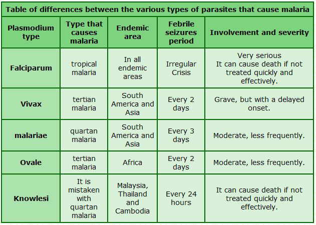
Types of malaria:
- Plasmodium falciparum
- Plasmodium vivax (the commonest ones)
- Plasmodium malariae
- Plasmodium ovale
- Plasmodium knowlesi.
-
Plasmodium ovale
- P ovale is very similar to P vivax, which is not a killer form
- P ovale is no more dangerous than getting a viral infection
- P ovale malaria is endemic to tropical Western Africa.
| According to National Vector-borne Disease Control Programme (NVBDCP) approximately 5 lakh people suffered from malaria (63% were of Plasmodium falciparum) in India.P. falciparum is the world’s most dangerous malaria parasite. |
Status of malaria in the world
- According to the World Malaria Report, nearly half of the world’s population continued to be at risk for the infection in 2021.
- The report said that there were an estimated 247 million cases across the world and 619,000 deaths due to malaria during the year.
- Around 95 per cent of these cases were from Africa.
- Malaria cases across the world went up from 2020, but at a slower rate than the year.
- More effective artemisinin-based combination therapies have been introduced, shorter course treatments for p. vivax have been developed, and a vaccine has been deployed for children living in regions with high transmission.
Status of Malaria in India
- Although malaria cases have been on the decline in India, there was an 85.1 per cent decline in malaria cases and an 83.36 per cent decline in deaths between 2015 and 2022.
- However, India is still one of the countries with a high burden of the infection.
- In 2021, 1.7 per cent of the malaria cases in the world and 1.2 per cent of all the deaths were reported in India
- Most malaria cases are mainly concentrated in tribal and remote areas of the country.
-
Six states along with tribal areas of MP and Maharashtra account for 90% disease burden:
- Odisha(40%), Jharkhand(20), Chhattisgarh(20), Meghalaya, AP & Mizoram(5-7%).
Topic 8: UN launches 10 principles to close Asia-Pacific sustainable finance gap
Why in news: A new report by the United Nations Economic and Social Commission for Asia and the Pacific (ESCAP) has put forward 10 principles for action for policymakers, regulators and private finance for mobilising and deploying financing for key UN-mandated Sustainable Development Goals, particularly around climate action.
Key details:
- The principles will help stakeholders cooperatively and efficiently shift and scale up capital to finance climate action by:
- reducing obstacles,
- addressing climate risk underpricing, and
- reducing sectoral and regional capital-investment mismatches.
-
Need for finance:
- Even as global emissions and energy needs rise, financing climate action in Asia and the Pacific has lagged due to macroeconomic challenges and public debt sustainability concerns.
- The principles put forward are:
- Developing new climate finance partnerships
- Developing effective NDC financing strategies
- Developing policy coherence and capacities across key government ministries
- Taking decisive regulatory action to shift capital in Asia and the Pacific towards the Net Zero transition
- Driving investment in the capacities of financial personnel
- Driving investment in much-needed sectoral and project-based financial data is undertaken
- Committing to Net Zero pledges for 2050 with credible transition pathways and including 2030 goals
- Increasing local-currency financing of energy transition projects as well as green technologies and other net-zero investments
- Expanding and accelerating concessional financing and risk-sharing by multilateral development banks, bilateral development financial institutions, and public development banks
- Increasing investment of time and effort with partners in project preparation
Findings of the report:
- Only 17 of the 51 Asia-Pacific countries party to the UN Framework Convention on Climate Change have assessed and reported their financial needs to meet their Nationally Determined Contributions.
- Only seven have broken down financial needs between adaptation and mitigation, the report said.
- Average economic losses in the region from disaster-related and other natural hazards are expected to rise to $1.1 trillion in a moderate climate-change scenario and $1.4 trillion in a worst-case scenario.
About United Nations Economic and Social Commission for Asia and the Pacific (ESCAP):
- The United Nations Economic and Social Commission for Asia and the Pacific (ESCAP) is one of the five regional commissions under the jurisdiction of the United Nations Economic and Social Council.
- It was established to increase economic activity in Asia and the Far East, as well as to foster economic relations between the region and other areas of the world.
- The commission is composed of 53 Member States and nine Associate members, mostly from the Asia and Pacific regions.
- In addition to countries in Asia and the Pacific, the commission’s members includes:
- France,
- the Netherlands,
- the United Kingdom and
- the United States.
- The region covered by the commission is home two-thirds of the world’s population, making ESCAP the most comprehensive of the United Nations’ five regional commissions.
- ESCAP operates in the following areas: